Kenai Mountains to Sea: Using Thermal Infrared Imagery to Implement Long-Term Salmon Conservation
Executive Summary
From Thermal Infrared Imagery to Conservation Actions
Cold water refugia, or areas within a stream that are persistently colder than surrounding areas, are critical features of wild salmon habitat throughout their range. Stream reaches with cold seeps and springs often result in much cooler water, which are increasingly important for wild salmon to keep cool as water temperatures in many streams have warmed. Some human activities can diminish or extinguish cold water refugia, such as groundwater withdrawal and construction of impervious surfaces. To conserve cold water refugia these sites must first be mapped and identified, and land owners and managers must understand best practices for their conservation.
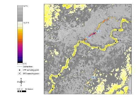
Since 2020, three community-based organizations - Cook Inletkeeper, Kachemak Heritage Land trust, and Kenai Watershed Forum - have worked together to identify where cold water refugia are found in the Kenai Peninsula lowlands, a region where productive wild salmon habitat intersects with a growing development footprint. We used cutting-edge methods to locate cold water refugia with thermal infrared imagery, a technology similar to night vision goggles that shows heat contrast. Our resulting “treasure map” of cold water refugia locations is a valuable tool for prioritizing conservation and outreach efforts.
In this project we focused our research on tributaries of the Kenai and Kasilof rivers; specifically, in the lower sections of streams outside of the federally-protected Kenai National Wildlife refuge as outlined in the Mountains to Sea planning document (Morton et al. 2015). Our goals for this project were to:
- Identify land parcels that contain one or more cold water refugia features, and communicate information about these features and possible conservation strategies to land owners; and
- Use a variety of techniques to communicate our results to over sixty landowners, agencies, and organizations.
Conservation actions that may result from these efforts include parcel acquisition and conservation easements, voluntary compliance, stewardship and restoration projects, and voluntary land agreements or exchanges.
The Future
Our efforts in applying thermal imagery data for conservation purposes highlights the value of recognizing cold water refugia as an asset for wild salmon habitat (Snyder et al. 2022). The work described here can continue to expand into additional watersheds: there are twenty river corridors of conservation priority described in the Mountains to Sea plan, while we possess aerial thermal infrared imagery on just five (the Anchor river plus the four rivers described in this report) (Mauger, McCarty, et al. 2015).
Beyond gathering additional thermal infrared imagery data , we recommend developing Alaska-specific technical and legal definitions, and applying them towards management needs. Two examples of potential applications follow:
Two examples of potential applications follow:
Example: Source Water Protection Areas
The U.S. Environmental Protection Agency (U.S. EPA) defines “Source Water Protection Areas” for groundwater sources used for drinking water, which delineate geographic areas that contribute to the drinking water supply1 . Similar logic could apply towards defining the extent of riparian landscape that supplies cold water refugia. Researchers with Kachemak Bay National Estuarine Research Reserve (KBNERR) in Homer, Alaska recently demonstrated that the extent of land that recharges cold water refugia can be delineated by use of a GIS-based model (Gerlach et al. 2021).
As of January 2023 the Kenai Peninsula Borough is in the process of reviewing its permitting process for material extraction sites (i.e. gravel pits). Initial discussions between the Borough and KBNERR have included the possibility of permit reviewers being able to use their maps of subterranean aquifer flow paths to comment on proposed development plans. This cooperation could help ensure that future development minimizes impact on the aquifers that supply cold water refugia, in the same way that defining Source Water Protection Areas help protect drinking water sources.
Example: Columbia River Cold Water Refugia
In an example from the Columbia River in the Pacific Northwest, the U.S. EPA has taken detailed steps to identify, define, and recommend conservation actions for cold water refugia. Here, cold water refugia were defined by quantitative flow volumes and their level of contrast with connected, warmer water bodies2. Such efforts could set an example for Alaska to follow in beginning to develop its own technical definitions of cold water refugia.
Existing efforts to technically define cold water refugia have focused on needs of adult upstream migration. However, salmon at all life stages benefit from a mosaic of water temperature environments, such as when juvenile fry migrate between colder and warmer and areas to feed and digest (Armstrong et al. 2013). Thus, it is recommended that future technical definitions also consider the needs of juvenile salmon.
Next Steps
We will continue to use our existing dataset to prioritize land conservation efforts in the Kenai Peninsula lowlands area. Through this project we have surveyed four river corridors of the 20 identified as conservation targets in the Kenai Mountains to Sea Strategic Plan. Specific actions that will support the goals of this project include:
Identifying where current, future, and retired material extraction sites (i.e. gravel pits) may influence conservation goals in the 20 Mountains to Sea corridors, and supporting efforts to include groundwater considerations in permit reviews.
Continue to communicate with staff at the Kenai National Wildlife Refuge who initiated an effort in 2022 to gather aerial thermal infrared imagery in local river corridors used by migrating adult Coho salmon3. A cost-effective collaboration could result if the Refuge’s aerial thermal imagery can be used for the same conservation goals as detailed in this project.
Continue to communicate with the Alaska Department of Environmental Conservation and other agencies about moving towards formally defined standards for cold water refugia.
Develop and publish standards for collection and application of thermal imagery in aquatic habitat, similar to published standards for stream temperature monitoring (Mauger, Shaftel, et al. 2015).
Convert the thermal imagery map files acquired from this project to a format accessible from an online web browser or Google Earth.
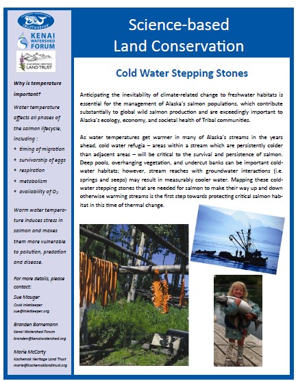
A two-page project summary titled, “Science Based Land Conservation: Cold Water Stepping Stones” is outlined below in Figure 1. In the online version of this report4, download a full size version of the information sheet by clicking on the link below.
https://www.epa.gov/sourcewaterprotection/delineate-source-water-protection-area↩︎
https://www.epa.gov/columbiariver/columbia-river-cold-water-refuges-plan↩︎
https://www.peninsulaclarion.com/sports/refuge-notebook-flying-a-remote-sensing-mission-on-the-refuge/↩︎
https://kenai-watershed-forum.github.io/kenai_thermal_imagery_v2/↩︎