| latitude | longitude | site_visits |
|---|---|---|
| 59.80044 | -151.6368 | 1 |
| 60.23948 | -151.4002 | 1 |
| 60.31038 | -151.2829 | 1 |
| 60.32300 | -151.2925 | 1 |
| 60.33330 | -151.2703 | 1 |
| 60.38256 | -151.1437 | 2 |
| 60.45573 | -150.2857 | 1 |
| 60.45829 | -150.8764 | 1 |
| 60.45978 | -151.0007 | 1 |
| 60.47904 | -151.1045 | 1 |
| 60.48221 | -151.1327 | 2 |
| 60.48335 | -151.0577 | 28 |
| 60.48335 | -151.0577 | 5 |
| 60.48361 | -151.0589 | 1 |
| 60.48365 | -151.0588 | 1 |
| 60.48365 | -151.0578 | 1 |
| 60.48367 | -151.0589 | 1 |
| 60.48393 | -149.9510 | 1 |
| 60.48407 | -149.8810 | 1 |
| 60.48984 | -149.7161 | 1 |
| 60.49506 | -150.9683 | 2 |
| 60.51334 | -150.8599 | 1 |
| 60.51828 | -150.8619 | 1 |
| 60.51832 | -150.8653 | 1 |
| 60.51855 | -150.8656 | 1 |
| 60.51903 | -150.8678 | 1 |
| 60.51912 | -150.8618 | 1 |
| 60.51988 | -150.8608 | 1 |
| 60.51994 | -150.8608 | 1 |
| 60.51998 | -150.8607 | 1 |
| 60.52009 | -150.8605 | 1 |
| 60.52017 | -150.8604 | 1 |
| 60.52018 | -150.8605 | 1 |
| 60.52025 | -150.8604 | 1 |
| 60.52027 | -150.8604 | 1 |
| 60.52127 | -150.8592 | 1 |
| 60.52231 | -151.0076 | 2 |
| 60.52338 | -151.0073 | 1 |
| 60.52371 | -151.0066 | 1 |
| 60.52383 | -150.8069 | 1 |
| 60.52383 | -150.8069 | 1 |
| 60.52387 | -150.8068 | 1 |
| 60.52505 | -151.0340 | 1 |
| 60.52515 | -151.0023 | 1 |
| 60.52522 | -151.0021 | 1 |
| 60.52770 | -150.9846 | 1 |
| 60.52771 | -150.9845 | 1 |
| 60.52940 | -151.0815 | 1 |
| 60.52947 | -151.0814 | 1 |
| 60.52959 | -151.0813 | 1 |
| 60.52965 | -151.0813 | 1 |
| 60.53088 | -150.9716 | 1 |
| 60.53527 | -150.9913 | 1 |
| 60.53681 | -150.7545 | 1 |
| 60.53752 | -151.0930 | 1 |
| 60.54171 | -151.1013 | 1 |
| 60.54179 | -151.1013 | 1 |
| 60.54179 | -151.1012 | 1 |
| 60.54184 | -151.1012 | 1 |
| 60.54188 | -151.1012 | 1 |
| 60.54188 | -150.9276 | 1 |
| 60.54194 | -151.1012 | 1 |
| 60.54223 | -150.9991 | 1 |
| 60.54227 | -151.2176 | 1 |
| 60.54229 | -151.2179 | 1 |
| 60.54231 | -151.2184 | 1 |
| 60.54235 | -151.2175 | 1 |
| 60.54237 | -151.2186 | 1 |
| 60.54254 | -151.2169 | 1 |
| 60.54257 | -151.2171 | 1 |
| 60.54259 | -151.2170 | 1 |
| 60.54763 | -150.7359 | 1 |
| 60.54817 | -151.1118 | 1 |
| 60.54928 | -150.7526 | 1 |
| 60.54931 | -150.7529 | 1 |
| 60.55241 | -150.7574 | 1 |
| 60.55580 | -150.9228 | 1 |
| 60.55695 | -150.9991 | 1 |
| 60.55808 | -150.6917 | 1 |
| 60.55918 | -150.9184 | 1 |
| 60.55926 | -150.7450 | 1 |
| 60.56000 | -150.6930 | 2 |
| 60.56007 | -151.1261 | 1 |
| 60.56039 | -150.7531 | 1 |
| 60.56094 | -150.7467 | 1 |
| 60.56126 | -150.6943 | 1 |
| 60.56302 | -150.6974 | 2 |
| 60.56372 | -150.7028 | 1 |
| 60.56560 | -151.2213 | 1 |
| 60.56600 | -151.2720 | 1 |
| 60.56605 | -151.2706 | 1 |
| 60.56958 | -151.1927 | 1 |
| 60.57007 | -151.1465 | 1 |
| 60.57484 | -151.1503 | 1 |
| 60.57522 | -151.1508 | 1 |
| 60.61200 | -151.1851 | 1 |
| 60.61241 | -151.0957 | 1 |
| 60.61379 | -151.1018 | 1 |
| 60.61383 | -151.1019 | 1 |
| 60.61425 | -151.1017 | 1 |
| 60.61509 | -151.0862 | 1 |
| 60.61714 | -151.0923 | 2 |
| 60.61751 | -151.0924 | 1 |
| 60.61867 | -151.0919 | 1 |
| 60.61916 | -151.0918 | 1 |
| 60.62021 | -151.0914 | 1 |
| 60.62061 | -151.0915 | 1 |
| 60.62218 | -151.0902 | 1 |
| 60.62227 | -151.0901 | 1 |
| 60.62237 | -151.0901 | 1 |
| 60.63943 | -151.3175 | 1 |
| 60.64064 | -151.0840 | 1 |
| 60.64234 | -149.4940 | 1 |
| 60.69047 | -151.3836 | 1 |
| 60.72671 | -149.3176 | 1 |
| 60.72763 | -151.1438 | 1 |
| 60.74132 | -149.2581 | 1 |
| 60.74143 | -149.2595 | 1 |
| 60.74159 | -149.2602 | 1 |
| 60.75166 | -151.1941 | 2 |
| 60.76791 | -151.0720 | 1 |
| 60.77243 | -151.0866 | 1 |
| 60.78960 | -149.2090 | 1 |
| 60.79425 | -150.9874 | 1 |
| 60.79575 | -149.1976 | 1 |
| 60.79600 | -149.1970 | 1 |
| 60.79624 | -149.1964 | 1 |
| 60.79638 | -149.1956 | 1 |
| 60.79644 | -149.1943 | 1 |
| 60.79725 | -149.1928 | 1 |
| 60.79753 | -150.9860 | 1 |
| 60.79807 | -149.1905 | 1 |
| 60.79812 | -149.1907 | 1 |
| 60.80034 | -149.2009 | 1 |
| 60.80138 | -149.2035 | 1 |
| 60.80197 | -149.2026 | 1 |
| 60.80209 | -150.9956 | 1 |
| 60.80230 | -149.2024 | 1 |
| 60.80279 | -149.2018 | 1 |
| 60.80317 | -149.2018 | 1 |
| 60.80345 | -149.2013 | 1 |
| 60.80358 | -149.2013 | 1 |
| 60.81345 | -150.6901 | 1 |
| 60.86992 | -150.5788 | 1 |
| 60.98049 | -150.4137 | 1 |
| NA | NA | 1 |
3 Results
Note: All fishing effort and capture results are current as of 2025-12-02.
3.1 Fish capture
During fieldwork in summers 2021 - 2025:
Over course of 93 fieldwork days 2021 - 2025 (including the training events), we conducted a total of 185 sampling events at 146 unique sites. See the interactive project map in the Methods section (“Site selection”) for a current map of where nominations have occurred.
Table Table 3.1 summarises total sampling events by individual site. We typically sampled a site only one time each.
We have captured 5104 fish comprised of 19 unique species. Table Table 3.2 summarizes current fish capture count by species.
Table Table 3.3 summarizes total fish capture for each species by site.
| species | n |
|---|---|
| Alaska blackfish | 23 |
| Chinook salmon | 34 |
| Dolly Varden | 119 |
| Other species not listed (please specify in comment column) | NA |
| Pacific salmon-unspecified | 227 |
| coho salmon | 991 |
| general fish observation, no species information | NA |
| lamprey-unspecified | 107 |
| ninespine stickleback | 69 |
| no fish collected or observed | NA |
| rainbow trout | 86 |
| salmonid, unspecified | 5 |
| sculpin-unspecified | 234 |
| slimy sculpin | 103 |
| sockeye salmon | 16 |
| steelhead (adult) | 9 |
| stickleback-unspecified | NA |
| threespine stickleback | 135 |
| wood frog | 3 |
| NA | NA |
| site | latitude | longitude | Alaska blackfish | Chinook salmon | Dolly Varden | Other species not listed (please specify in comment column) | Pacific salmon-unspecified | coho salmon | general fish observation, no species information | lamprey-unspecified | ninespine stickleback | no fish collected or observed | rainbow trout | salmonid, unspecified | sculpin-unspecified | slimy sculpin | sockeye salmon | steelhead (adult) | stickleback-unspecified | threespine stickleback | wood frog |
|---|---|---|---|---|---|---|---|---|---|---|---|---|---|---|---|---|---|---|---|---|---|
| 60.5423451164853,-151.217527966964 | 60.54235 | -151.2175 | 6 | 0 | 0 | 0 | 0 | 1 | 0 | 0 | 0 | 0 | 0 | 0 | 1 | 0 | 0 | 0 | 0 | 0 | 0 |
| 60.5423732835192,-151.218556433759 | 60.54237 | -151.2186 | 1 | 0 | 0 | 0 | 0 | 0 | 0 | 0 | 0 | 0 | 0 | 0 | 16 | 0 | 0 | 0 | 0 | 0 | 0 |
| 60.5425873166579,-151.21697603307 | 60.54259 | -151.2170 | 6 | 0 | 0 | 0 | 0 | 3 | 0 | 0 | 3 | 0 | 0 | 0 | 0 | 0 | 0 | 0 | 0 | 0 | 0 |
| Beaver Creek Trib Marathon | 60.61200 | -151.1851 | 1 | 0 | 0 | 0 | 0 | 0 | 0 | 0 | 1 | 0 | 0 | 0 | 0 | 0 | 0 | 0 | 0 | 0 | 0 |
| Candlelight - Downstream | 60.56958 | -151.1927 | 1 | 0 | 0 | 0 | 0 | 0 | 0 | 0 | 0 | 0 | 0 | 0 | 0 | 0 | 0 | 0 | 0 | 0 | 0 |
| WalMart Creek | 60.56560 | -151.2213 | 8 | 0 | 0 | 0 | 0 | 0 | 0 | 0 | 0 | 0 | 0 | 2 | 0 | 0 | 0 | 0 | 0 | 0 | 0 |
| 60.5375230001773,-151.092986166591 | 60.53752 | -151.0930 | 0 | 2 | 0 | 0 | 0 | 1 | 0 | 0 | 0 | 0 | 1 | 0 | 5 | 0 | 0 | 1 | 0 | 0 | 0 |
| 60.6150878335298,-151.086157000426 | 60.61509 | -151.0862 | 0 | 1 | 0 | 0 | 0 | 0 | 0 | 0 | 0 | 0 | 8 | 0 | 3 | 0 | 0 | 8 | 0 | 0 | 0 |
| Centennial Park Launch | 60.47904 | -151.1045 | 0 | 6 | 0 | 0 | 0 | 0 | 0 | 0 | 0 | 0 | 0 | 0 | 0 | 0 | 0 | 0 | 0 | 2 | 0 |
| Crooked Creek Trib 1.2 | 60.31038 | -151.2829 | 0 | 1 | 0 | 0 | 0 | 2 | 0 | 0 | 0 | 0 | 0 | 0 | 0 | 0 | 0 | 0 | 0 | 0 | 0 |
| Lower Soldotna Creek | 60.48335 | -151.0577 | 0 | 19 | 10 | 0 | 1 | 423 | 0 | 7 | 3 | 0 | 47 | 3 | 96 | 76 | 16 | 0 | 15 | 12 | 0 |
| Lower Soldotna Creek | 60.48335 | -151.0577 | 0 | 3 | 1 | 0 | 0 | 120 | 0 | 0 | 0 | 0 | 3 | 0 | 38 | 0 | 0 | 0 | 1 | 6 | 0 |
| Soldotna Creek Mouth | 60.48335 | -151.0577 | 0 | 2 | 0 | 0 | 0 | 86 | 0 | 0 | 0 | 0 | 3 | 0 | 43 | 0 | 0 | 0 | 2 | 1 | 0 |
| 60.7413154515577,-149.258106546279 | 60.74132 | -149.2581 | 0 | 0 | 5 | 0 | 0 | 0 | 0 | 0 | 0 | 0 | 0 | 0 | 0 | 0 | 0 | 0 | 0 | 0 | 0 |
| 60.7414343794077,-149.259513932343 | 60.74143 | -149.2595 | 0 | 0 | 2 | 0 | 0 | 0 | 0 | 0 | 0 | 0 | 0 | 0 | 0 | 0 | 0 | 0 | 0 | 0 | 0 |
| 60.7415854743461,-149.260157850129 | 60.74159 | -149.2602 | 0 | 0 | 5 | 0 | 0 | 0 | 0 | 0 | 0 | 0 | 0 | 0 | 0 | 0 | 0 | 0 | 0 | 0 | 0 |
| 60.7957461664763,-149.197589833061 | 60.79575 | -149.1976 | 0 | 0 | 2 | 0 | 0 | 1 | 0 | 0 | 0 | 0 | 0 | 0 | 0 | 0 | 0 | 0 | 0 | 0 | 0 |
| 60.7960016668789,-149.197044166713 | 60.79600 | -149.1970 | 0 | 0 | 1 | 0 | 0 | 1 | 0 | 0 | 0 | 0 | 0 | 0 | 0 | 0 | 0 | 0 | 0 | 0 | 0 |
| 60.7981191665113,-149.190669000109 | 60.79812 | -149.1907 | 0 | 0 | 1 | 0 | 0 | 1 | 0 | 0 | 0 | 0 | 0 | 0 | 0 | 0 | 0 | 0 | 0 | 0 | 0 |
| 60.8019742103104,-149.202574834304 | 60.80197 | -149.2026 | 0 | 0 | 9 | 0 | 0 | 0 | 0 | 0 | 0 | 0 | 0 | 0 | 0 | 0 | 0 | 0 | 0 | 0 | 0 |
| 60.8023024267097,-149.202392704473 | 60.80230 | -149.2024 | 0 | 0 | 8 | 0 | 0 | 0 | 0 | 0 | 0 | 0 | 0 | 0 | 0 | 0 | 0 | 0 | 0 | 0 | 0 |
| 60.8031739661773,-149.201819101418 | 60.80317 | -149.2018 | 0 | 0 | 3 | 0 | 0 | 0 | 0 | 0 | 0 | 0 | 0 | 0 | 0 | 0 | 0 | 0 | 0 | 0 | 0 |
| 60.8034507781268,-149.201317096786 | 60.80345 | -149.2013 | 0 | 0 | 4 | 0 | 0 | 0 | 0 | 0 | 0 | 0 | 0 | 0 | 0 | 0 | 0 | 0 | 0 | 0 | 0 |
| 60.8035789399961,-149.201250619659 | 60.80358 | -149.2013 | 0 | 0 | 2 | 0 | 0 | 0 | 0 | 0 | 0 | 0 | 0 | 0 | 0 | 0 | 0 | 0 | 0 | 0 | 0 |
| Clam Gulch Creek 1 | 60.23948 | -151.4002 | 0 | 0 | 1 | 0 | 0 | 12 | 0 | 0 | 0 | 0 | 0 | 0 | 0 | 0 | 0 | 0 | 1 | 0 | 0 |
| Cooper Creek Mouth | 60.48407 | -149.8810 | 0 | 0 | 1 | 0 | 0 | 5 | 0 | 0 | 0 | 0 | 3 | 0 | 2 | 0 | 0 | 0 | 0 | 0 | 0 |
| Forestner Culvert - Downstream | 60.52387 | -150.8068 | 0 | 0 | 2 | 0 | 0 | 6 | 0 | 0 | 0 | 0 | 0 | 0 | 0 | 0 | 0 | 0 | 0 | 0 | 0 |
| Funny River Rd Trib 1.1 | 60.45978 | -151.0007 | 0 | 0 | 5 | 0 | 0 | 2 | 0 | 0 | 0 | 0 | 0 | 0 | 0 | 0 | 0 | 0 | 0 | 0 | 0 |
| Granite Creek 1.1 | 60.80138 | -149.2035 | 0 | 0 | 4 | 0 | 0 | 5 | 0 | 0 | 0 | 0 | 0 | 0 | 0 | 0 | 0 | 0 | 0 | 0 | 0 |
| Granite Creek 4.1 | 60.78960 | -149.2090 | 0 | 0 | 4 | 0 | 0 | 5 | 0 | 0 | 0 | 0 | 0 | 0 | 0 | 0 | 0 | 0 | 0 | 0 | 0 |
| Isbell 1 | 60.49506 | -150.9683 | 0 | 0 | 4 | 0 | 0 | 3 | 0 | 0 | 0 | 0 | 0 | 0 | 0 | 0 | 0 | 0 | 0 | 0 | 0 |
| KNWR Trib 1 | 60.45829 | -150.8764 | 0 | 0 | 2 | 0 | 0 | 3 | 0 | 0 | 4 | 0 | 0 | 0 | 2 | 0 | 0 | 0 | 0 | 0 | 0 |
| Moose River Trib 1 | 60.56372 | -150.7028 | 0 | 0 | 1 | 0 | 0 | 7 | 0 | 0 | 0 | 0 | 0 | 0 | 0 | 0 | 0 | 0 | 0 | 0 | 0 |
| Moose River Trib 1.2 | 60.56126 | -150.6943 | 0 | 0 | 1 | 0 | 0 | 5 | 0 | 0 | 0 | 0 | 0 | 0 | 0 | 0 | 0 | 0 | 0 | 0 | 0 |
| Moose River Trib 1.3 | 60.56302 | -150.6974 | 0 | 0 | 2 | 0 | 0 | 18 | 0 | 0 | 0 | 0 | 1 | 0 | 0 | 0 | 0 | 0 | 0 | 0 | 0 |
| Moose River Trib 1.5 | 60.55808 | -150.6917 | 0 | 0 | 3 | 0 | 0 | 6 | 0 | 0 | 0 | 0 | 0 | 0 | 0 | 0 | 0 | 0 | 0 | 0 | 0 |
| Moose River Trib 2.1 | 60.55926 | -150.7450 | 0 | 0 | 1 | 0 | 0 | 2 | 0 | 0 | 0 | 0 | 0 | 0 | 0 | 0 | 0 | 0 | 0 | 0 | 0 |
| Moose River Trib 2.2 | 60.56039 | -150.7531 | 0 | 0 | 3 | 0 | 0 | 4 | 0 | 0 | 0 | 0 | 0 | 0 | 0 | 0 | 0 | 0 | 0 | 0 | 0 |
| Moose River Trib 2.3 | 60.56094 | -150.7467 | 0 | 0 | 1 | 0 | 0 | 13 | 0 | 0 | 0 | 0 | 0 | 0 | 0 | 0 | 0 | 0 | 0 | 0 | 0 |
| Otter Trail 1 | 60.54763 | -150.7359 | 0 | 0 | 2 | 0 | 0 | 20 | 0 | 0 | 4 | 0 | 0 | 0 | 0 | 0 | 0 | 0 | 0 | 0 | 0 |
| Sixmile Trib 2 | 60.72671 | -149.3176 | 0 | 0 | 2 | 0 | 0 | 58 | 0 | 0 | 0 | 0 | 0 | 0 | 0 | 0 | 0 | 0 | 0 | 0 | 0 |
| Slikok Creek Platform | 60.48221 | -151.1327 | 0 | 0 | 1 | 0 | 0 | 11 | 0 | 0 | 1 | 0 | 0 | 0 | 5 | 0 | 0 | 0 | 0 | 1 | 0 |
| Unnamed Kenai Trib 1.1 | 60.51832 | -150.8653 | 0 | 0 | 18 | 0 | 0 | 7 | 0 | 0 | 0 | 0 | 0 | 0 | 0 | 0 | 0 | 0 | 0 | 0 | 0 |
| Unnamed Kenai Trib 1.2 | 60.51828 | -150.8619 | 0 | 0 | 1 | 0 | 0 | 4 | 0 | 0 | 0 | 0 | 0 | 0 | 0 | 0 | 0 | 0 | 0 | 0 | 0 |
| Upper Ohmer Lake | 60.45573 | -150.2857 | 0 | 0 | 2 | 0 | 0 | 0 | 0 | 0 | 0 | 0 | 4 | 0 | 0 | 0 | 0 | 0 | 0 | 0 | 0 |
| Upper Soldotna Creek 1 | 60.55580 | -150.9228 | 0 | 0 | 5 | 0 | 0 | 16 | 0 | 0 | 0 | 0 | 0 | 0 | 0 | 0 | 0 | 0 | 37 | 0 | 0 |
| 60.6206078331563,-151.091485167091 | 60.62061 | -151.0915 | 0 | 0 | 0 | 0 | 0 | 0 | 0 | 0 | 0 | 0 | 0 | 0 | 0 | 0 | 0 | 0 | 0 | 0 | 0 |
| Eagle Rock Stream | 60.54817 | -151.1118 | 0 | 0 | 0 | 0 | 1 | 2 | 0 | 0 | 2 | 0 | 0 | 0 | 0 | 1 | 0 | 0 | 0 | 0 | 0 |
| North Fork Anchor River | 59.80044 | -151.6368 | 0 | 0 | 0 | 0 | 225 | 0 | 0 | 100 | 0 | 0 | 0 | 0 | 4 | 0 | 0 | 0 | 0 | 0 | 0 |
| 60.523832333471,-150.806871667027 | 60.52383 | -150.8069 | 0 | 0 | 0 | 0 | 0 | 1 | 0 | 0 | 0 | 0 | 0 | 0 | 0 | 0 | 0 | 0 | 0 | 0 | 0 |
| 60.5422709165395,-151.217612716722 | 60.54227 | -151.2176 | 0 | 0 | 0 | 0 | 0 | 5 | 0 | 0 | 6 | 0 | 0 | 0 | 3 | 0 | 0 | 0 | 0 | 0 | 0 |
| 60.5423104164717,-151.218394516921 | 60.54231 | -151.2184 | 0 | 0 | 0 | 0 | 0 | 2 | 0 | 0 | 6 | 0 | 0 | 0 | 4 | 0 | 0 | 0 | 0 | 0 | 0 |
| 60.7962438333778,-149.196412333064 | 60.79624 | -149.1964 | 0 | 0 | 0 | 0 | 0 | 1 | 0 | 0 | 0 | 0 | 0 | 0 | 0 | 0 | 0 | 0 | 0 | 0 | 0 |
| 60.796384833452,-149.195572166627 | 60.79638 | -149.1956 | 0 | 0 | 0 | 0 | 0 | 2 | 0 | 0 | 0 | 0 | 0 | 0 | 0 | 0 | 0 | 0 | 0 | 0 | 0 |
| 60.797248000059,-149.192795333048 | 60.79725 | -149.1928 | 0 | 0 | 0 | 0 | 0 | 1 | 0 | 0 | 0 | 0 | 0 | 0 | 0 | 0 | 0 | 0 | 0 | 0 | 0 |
| Beaver Creek MT #10 | 60.61714 | -151.0923 | 0 | 0 | 0 | 0 | 0 | 15 | 0 | 0 | 13 | 0 | 0 | 0 | 1 | 0 | 0 | 0 | 0 | 0 | 0 |
| Beaver Creek Trib 1.1 | 60.57007 | -151.1465 | 0 | 0 | 0 | 0 | 0 | 11 | 0 | 0 | 17 | 0 | 0 | 0 | 0 | 0 | 0 | 0 | 0 | 0 | 0 |
| Beaver Creek Trib 1.2 | 60.57484 | -151.1503 | 0 | 0 | 0 | 0 | 0 | 3 | 0 | 0 | 1 | 0 | 0 | 0 | 0 | 0 | 0 | 0 | 0 | 0 | 0 |
| Beaver Creek Trib 1.3 | 60.57522 | -151.1508 | 0 | 0 | 0 | 0 | 0 | 6 | 0 | 0 | 0 | 0 | 0 | 0 | 0 | 0 | 0 | 0 | 0 | 0 | 0 |
| Coal Creek Trib 1 | 60.38256 | -151.1437 | 0 | 0 | 0 | 0 | 0 | 17 | 0 | 0 | 0 | 0 | 0 | 0 | 2 | 0 | 0 | 0 | 3 | 0 | 0 |
| Derks Lake Outlet | 60.53088 | -150.9716 | 0 | 0 | 0 | 0 | 0 | 2 | 0 | 0 | 0 | 0 | 0 | 0 | 0 | 0 | 0 | 0 | 160 | 0 | 0 |
| Dolly Varden Way - Upstream | 60.52770 | -150.9846 | 0 | 0 | 0 | 0 | 0 | 2 | 0 | 0 | 0 | 0 | 0 | 0 | 0 | 0 | 0 | 0 | 8 | 0 | 0 |
| Forestner Culvert - Upstream | 60.52383 | -150.8069 | 0 | 0 | 0 | 0 | 0 | 7 | 0 | 0 | 0 | 0 | 0 | 0 | 0 | 0 | 0 | 0 | 0 | 0 | 0 |
| Kasilof Trib 2 | 60.32300 | -151.2925 | 0 | 0 | 0 | 0 | 0 | 4 | 0 | 0 | 0 | 0 | 0 | 0 | 0 | 0 | 0 | 0 | 0 | 0 | 0 |
| Lower Beaver Creek | 60.56007 | -151.1261 | 0 | 0 | 0 | 0 | 0 | 16 | 0 | 0 | 0 | 0 | 1 | 0 | 0 | 2 | 0 | 0 | 0 | 0 | 0 |
| Mackey Lakes Culvet - Downstream | 60.52522 | -151.0021 | 0 | 0 | 0 | 0 | 0 | 7 | 0 | 0 | 0 | 0 | 7 | 0 | 0 | 0 | 0 | 0 | 179 | 0 | 0 |
| Moose River Trib 1.4 | 60.56000 | -150.6930 | 0 | 0 | 0 | 0 | 0 | 9 | 0 | 0 | 0 | 0 | 0 | 0 | 0 | 0 | 0 | 0 | 0 | 0 | 0 |
| Moose River Trib 3.1 - Downstream | 60.54928 | -150.7526 | 0 | 0 | 0 | 0 | 0 | 1 | 0 | 0 | 0 | 0 | 0 | 0 | 0 | 0 | 0 | 0 | 0 | 0 | 0 |
| No Name Creek (Shqui Tsaina) | 60.56600 | -151.2720 | 0 | 0 | 0 | 0 | 0 | 1 | 0 | 0 | 0 | 0 | 0 | 0 | 0 | 0 | 0 | 0 | 0 | 0 | 0 |
| North Nikiski Lake 1.1 | 60.80209 | -150.9956 | 0 | 0 | 0 | 0 | 0 | 2 | 0 | 0 | 0 | 0 | 1 | 0 | 0 | 9 | 0 | 0 | 0 | 0 | 0 |
| North Nikiski Lake 1.2 | 60.79753 | -150.9860 | 0 | 0 | 0 | 0 | 0 | 2 | 0 | 0 | 0 | 0 | 0 | 0 | 0 | 9 | 0 | 0 | 0 | 49 | 0 |
| Resurrection Pass Bridge | 60.48393 | -149.9510 | 0 | 0 | 0 | 0 | 0 | 1 | 0 | 0 | 0 | 0 | 0 | 0 | 5 | 0 | 0 | 0 | 0 | 0 | 0 |
| Savena Lake Trib | 60.55695 | -150.9991 | 0 | 0 | 0 | 0 | 0 | 10 | 0 | 0 | 0 | 0 | 0 | 0 | 0 | 0 | 0 | 0 | 18 | 0 | 0 |
| Tree Lake | 60.55918 | -150.9184 | 0 | 0 | 0 | 0 | 0 | 1 | 0 | 0 | 0 | 0 | 0 | 0 | 0 | 0 | 0 | 0 | 75 | 0 | 0 |
| West Fork Beaver Creek Bridge - Upstream | 60.64064 | -151.0840 | 0 | 0 | 0 | 0 | 0 | 3 | 0 | 0 | 0 | 0 | 0 | 0 | 0 | 0 | 0 | 0 | 0 | 0 | 0 |
| West Mackey Lake | 60.52338 | -151.0073 | 0 | 0 | 0 | 0 | 0 | 3 | 0 | 0 | 0 | 0 | 0 | 0 | 0 | 0 | 0 | 0 | 200 | 0 | 0 |
| West Mackey Lake 2 | 60.52371 | -151.0066 | 0 | 0 | 0 | 0 | 0 | 3 | 0 | 0 | 0 | 0 | 0 | 0 | 0 | 0 | 0 | 0 | 103 | 0 | 0 |
| 60.5422911657167,-151.217940391595 | 60.54229 | -151.2179 | 0 | 0 | 0 | 0 | 0 | 0 | 0 | 0 | 2 | 0 | 0 | 0 | 3 | 0 | 0 | 0 | 0 | 0 | 0 |
| Shqui Tsatnu | 60.56605 | -151.2706 | 0 | 0 | 0 | 0 | 0 | 0 | 0 | 0 | 4 | 0 | 0 | 0 | 0 | 0 | 0 | 0 | 0 | 0 | 0 |
| Unknown Nikiski Lake 1 | 60.77243 | -151.0866 | 0 | 0 | 0 | 0 | 0 | 0 | 0 | 0 | 2 | 0 | 0 | 0 | 0 | 0 | 0 | 0 | 0 | 0 | 0 |
| Bird Lake | 60.98049 | -150.4137 | 0 | 0 | 0 | 0 | 0 | 0 | 0 | 0 | 0 | 0 | 2 | 0 | 0 | 0 | 0 | 0 | 3 | 0 | 0 |
| Summit Lake Outlet | 60.64234 | -149.4940 | 0 | 0 | 0 | 0 | 0 | 0 | 0 | 0 | 0 | 0 | 5 | 0 | 0 | 0 | 0 | 0 | 1 | 0 | 0 |
| 60.5368105858248,-150.754533535057 | 60.53681 | -150.7545 | 0 | 0 | 0 | 0 | 0 | 0 | 0 | 0 | 0 | 0 | 0 | 0 | 1 | 0 | 0 | 0 | 3 | 0 | 0 |
| McLain Lake NE | 60.86992 | -150.5788 | 0 | 0 | 0 | 0 | 0 | 0 | 0 | 0 | 0 | 0 | 0 | 0 | 0 | 2 | 0 | 0 | 194 | 0 | 0 |
| North Nikiski Lake 2 | 60.79425 | -150.9874 | 0 | 0 | 0 | 0 | 0 | 0 | 0 | 0 | 0 | 0 | 0 | 0 | 0 | 2 | 0 | 0 | 8 | 0 | 0 |
| Snag Lake South | 60.81345 | -150.6901 | 0 | 0 | 0 | 0 | 0 | 0 | 0 | 0 | 0 | 0 | 0 | 0 | 0 | 2 | 0 | 0 | 44 | 0 | 0 |
| 60.6191638332369,-151.091797000174 | 60.61916 | -151.0918 | 0 | 0 | 0 | 0 | 0 | 0 | 0 | 0 | 0 | 0 | 0 | 0 | 0 | 0 | 0 | 0 | 1 | 0 | 1 |
| 60.6221846664509,-151.090153332935 | 60.62218 | -151.0902 | 0 | 0 | 0 | 0 | 0 | 0 | 0 | 0 | 0 | 0 | 0 | 0 | 0 | 0 | 0 | 0 | 0 | 0 | 0 |
| 60.6222674998185,-151.090121500235 | 60.62227 | -151.0901 | 0 | 0 | 0 | 0 | 0 | 0 | 0 | 0 | 0 | 0 | 0 | 0 | 0 | 0 | 0 | 0 | 1 | 0 | 0 |
| Bernice Culvert | 60.69047 | -151.3836 | 0 | 0 | 0 | 0 | 0 | 0 | 0 | 0 | 0 | 0 | 0 | 0 | 0 | 0 | 0 | 0 | 51 | 0 | 0 |
| Dolly Varden Way - Downstream | 60.52771 | -150.9845 | 0 | 0 | 0 | 0 | 0 | 0 | 0 | 0 | 0 | 0 | 0 | 0 | 0 | 0 | 0 | 0 | 20 | 0 | 0 |
| East Mackey Lake | 60.53527 | -150.9913 | 0 | 0 | 0 | 0 | 0 | 0 | 0 | 0 | 0 | 0 | 0 | 0 | 0 | 0 | 0 | 0 | 99 | 0 | 0 |
| Mackey Lakes Crossing - Upstream | 60.52515 | -151.0023 | 0 | 0 | 0 | 0 | 0 | 0 | 0 | 0 | 0 | 0 | 0 | 0 | 0 | 0 | 0 | 0 | 28 | 0 | 0 |
| Salamatof Creek | 60.63943 | -151.3175 | 0 | 0 | 0 | 0 | 0 | 0 | 0 | 0 | 0 | 0 | 0 | 0 | 0 | 0 | 0 | 0 | 445 | 0 | 0 |
| Sevena lake Trib 2 | 60.54223 | -150.9991 | 0 | 0 | 0 | 0 | 0 | 0 | 0 | 0 | 0 | 0 | 0 | 0 | 0 | 0 | 0 | 0 | 14 | 0 | 0 |
| South Mackey Pond | 60.52231 | -151.0076 | 0 | 0 | 0 | 0 | 0 | 0 | 0 | 0 | 0 | 0 | 0 | 0 | 0 | 0 | 0 | 0 | 168 | 0 | 0 |
| Suneva Lake | 60.75166 | -151.1941 | 0 | 0 | 0 | 0 | 0 | 0 | 0 | 0 | 0 | 0 | 0 | 0 | 0 | 0 | 0 | 0 | 10 | 51 | 0 |
| Union Lake 1 | 60.52505 | -151.0340 | 0 | 0 | 0 | 0 | 0 | 0 | 0 | 0 | 0 | 0 | 0 | 0 | 0 | 0 | 0 | 0 | 1009 | 0 | 0 |
| Unknown Nikiski Lake 2 | 60.76791 | -151.0720 | 0 | 0 | 0 | 0 | 0 | 0 | 0 | 0 | 0 | 0 | 0 | 0 | 0 | 0 | 0 | 0 | 7 | 8 | 0 |
| soldotna_creek2 | 60.54188 | -150.9276 | 0 | 0 | 0 | 0 | 0 | 0 | 0 | 0 | 0 | 0 | 0 | 0 | 0 | 0 | 0 | 0 | 35 | 0 | 0 |
| Kasilof Trib 1.1 | 60.33330 | -151.2703 | 0 | 0 | 0 | 0 | 0 | 0 | 0 | 0 | 0 | 0 | 0 | 0 | 0 | 0 | 0 | 0 | 0 | 3 | 0 |
| West Beck Lake 2 | 60.72763 | -151.1438 | 0 | 0 | 0 | 0 | 0 | 0 | 0 | 0 | 0 | 0 | 0 | 0 | 0 | 0 | 0 | 0 | 0 | 2 | 0 |
| 60.6223748335068,-151.09008166624 | 60.62237 | -151.0901 | 0 | 0 | 0 | 0 | 0 | 0 | 0 | 0 | 0 | 0 | 0 | 0 | 0 | 0 | 0 | 0 | 0 | 0 | 2 |
| 60.4836089833584,-151.058868583291 | 60.48361 | -151.0589 | 0 | 0 | 0 | 0 | 0 | 0 | 0 | 0 | 0 | 0 | 0 | 0 | 0 | 0 | 0 | 0 | 0 | 0 | 0 |
| 60.4836546668301,-151.058816833144 | 60.48365 | -151.0588 | 0 | 0 | 0 | 0 | 0 | 0 | 0 | 0 | 0 | 0 | 0 | 0 | 0 | 0 | 0 | 0 | 0 | 0 | 0 |
| 60.4836548677589,-151.057820180184 | 60.48365 | -151.0578 | 0 | 0 | 0 | 0 | 0 | 0 | 0 | 0 | 0 | 0 | 0 | 0 | 0 | 0 | 0 | 0 | 0 | 0 | 0 |
| 60.4836668332046,-151.058852333666 | 60.48367 | -151.0589 | 0 | 0 | 0 | 0 | 0 | 0 | 0 | 0 | 0 | 0 | 0 | 0 | 0 | 0 | 0 | 0 | 0 | 0 | 0 |
| 60.48983684136,-149.716090663317 | 60.48984 | -149.7161 | 0 | 0 | 0 | 0 | 0 | 0 | 0 | 0 | 0 | 0 | 0 | 0 | 0 | 0 | 0 | 0 | 0 | 0 | 0 |
| 60.5133439460281,-150.859893271401 | 60.51334 | -150.8599 | 0 | 0 | 0 | 0 | 0 | 0 | 0 | 0 | 0 | 0 | 0 | 0 | 0 | 0 | 0 | 0 | 0 | 0 | 0 |
| 60.5185531665679,-150.865639666713 | 60.51855 | -150.8656 | 0 | 0 | 0 | 0 | 0 | 0 | 0 | 0 | 0 | 0 | 0 | 0 | 0 | 0 | 0 | 0 | 0 | 0 | 0 |
| 60.5190314998128,-150.867780333171 | 60.51903 | -150.8678 | 0 | 0 | 0 | 0 | 0 | 0 | 0 | 0 | 0 | 0 | 0 | 0 | 0 | 0 | 0 | 0 | 0 | 0 | 0 |
| 60.5191188331783,-150.861787833607 | 60.51912 | -150.8618 | 0 | 0 | 0 | 0 | 0 | 0 | 0 | 0 | 0 | 0 | 0 | 0 | 0 | 0 | 0 | 0 | 0 | 0 | 0 |
| 60.5198751668078,-150.860827666621 | 60.51988 | -150.8608 | 0 | 0 | 0 | 0 | 0 | 0 | 0 | 0 | 0 | 0 | 0 | 0 | 0 | 0 | 0 | 0 | 0 | 0 | 0 |
| 60.5199434999825,-150.860761999773 | 60.51994 | -150.8608 | 0 | 0 | 0 | 0 | 0 | 0 | 0 | 0 | 0 | 0 | 0 | 0 | 0 | 0 | 0 | 0 | 0 | 0 | 0 |
| 60.5199826668706,-150.860682166494 | 60.51998 | -150.8607 | 0 | 0 | 0 | 0 | 0 | 0 | 0 | 0 | 0 | 0 | 0 | 0 | 0 | 0 | 0 | 0 | 0 | 0 | 0 |
| 60.5200878332918,-150.86050333348 | 60.52009 | -150.8605 | 0 | 0 | 0 | 0 | 0 | 0 | 0 | 0 | 0 | 0 | 0 | 0 | 0 | 0 | 0 | 0 | 0 | 0 | 0 |
| 60.5201656666832,-150.860427666587 | 60.52017 | -150.8604 | 0 | 0 | 0 | 0 | 0 | 0 | 0 | 0 | 0 | 0 | 0 | 0 | 0 | 0 | 0 | 0 | 0 | 0 | 0 |
| 60.5201821667387,-150.86045083324 | 60.52018 | -150.8605 | 0 | 0 | 0 | 0 | 0 | 0 | 0 | 0 | 0 | 0 | 0 | 0 | 0 | 0 | 0 | 0 | 0 | 0 | 0 |
| 60.5202457920482,-150.860424536857 | 60.52025 | -150.8604 | 0 | 0 | 0 | 0 | 0 | 0 | 0 | 0 | 0 | 0 | 0 | 0 | 0 | 0 | 0 | 0 | 0 | 0 | 0 |
| 60.5202666345661,-150.860350736663 | 60.52027 | -150.8604 | 0 | 0 | 0 | 0 | 0 | 0 | 0 | 0 | 0 | 0 | 0 | 0 | 0 | 0 | 0 | 0 | 0 | 0 | 0 |
| 60.52127209827,-150.859240390226 | 60.52127 | -150.8592 | 0 | 0 | 0 | 0 | 0 | 0 | 0 | 0 | 0 | 0 | 0 | 0 | 0 | 0 | 0 | 0 | 0 | 0 | 0 |
| 60.5294026665651,-151.081506167079 | 60.52940 | -151.0815 | 0 | 0 | 0 | 0 | 0 | 0 | 0 | 0 | 0 | 0 | 0 | 0 | 0 | 0 | 0 | 0 | 0 | 0 | 0 |
| 60.5294728331745,-151.081384500155 | 60.52947 | -151.0814 | 0 | 0 | 0 | 0 | 0 | 0 | 0 | 0 | 0 | 0 | 0 | 0 | 0 | 0 | 0 | 0 | 0 | 0 | 0 |
| 60.5295859998577,-151.081322833505 | 60.52959 | -151.0813 | 0 | 0 | 0 | 0 | 0 | 0 | 0 | 0 | 0 | 0 | 0 | 0 | 0 | 0 | 0 | 0 | 0 | 0 | 0 |
| 60.5296468334764,-151.081300499591 | 60.52965 | -151.0813 | 0 | 0 | 0 | 0 | 0 | 0 | 0 | 0 | 0 | 0 | 0 | 0 | 0 | 0 | 0 | 0 | 0 | 0 | 0 |
| 60.5417069999622,-151.101298166524 | 60.54171 | -151.1013 | 0 | 0 | 0 | 0 | 0 | 0 | 0 | 0 | 0 | 0 | 0 | 0 | 0 | 0 | 0 | 0 | 0 | 0 | 0 |
| 60.5417881667668,-151.101257499791 | 60.54179 | -151.1013 | 0 | 0 | 0 | 0 | 0 | 0 | 0 | 0 | 0 | 0 | 0 | 0 | 0 | 0 | 0 | 0 | 0 | 0 | 0 |
| 60.5417883333183,-151.101223666542 | 60.54179 | -151.1012 | 0 | 0 | 0 | 0 | 0 | 0 | 0 | 0 | 0 | 0 | 0 | 0 | 0 | 0 | 0 | 0 | 0 | 0 | 0 |
| 60.5418363332576,-151.101235666238 | 60.54184 | -151.1012 | 0 | 0 | 0 | 0 | 0 | 0 | 0 | 0 | 0 | 0 | 0 | 0 | 0 | 0 | 0 | 0 | 0 | 0 | 0 |
| 60.5418780002095,-151.101230166751 | 60.54188 | -151.1012 | 0 | 0 | 0 | 0 | 0 | 0 | 0 | 0 | 0 | 0 | 0 | 0 | 0 | 0 | 0 | 0 | 0 | 0 | 0 |
| 60.5419361666829,-151.101186666732 | 60.54194 | -151.1012 | 0 | 0 | 0 | 0 | 0 | 0 | 0 | 0 | 0 | 0 | 0 | 0 | 0 | 0 | 0 | 0 | 0 | 0 | 0 |
| 60.5425407257567,-151.216868418492 | 60.54254 | -151.2169 | 0 | 0 | 0 | 0 | 0 | 0 | 0 | 0 | 0 | 0 | 0 | 0 | 0 | 0 | 0 | 0 | 0 | 0 | 0 |
| 60.5425688829015,-151.217114913511 | 60.54257 | -151.2171 | 0 | 0 | 0 | 0 | 0 | 0 | 0 | 0 | 0 | 0 | 0 | 0 | 0 | 0 | 0 | 0 | 0 | 0 | 0 |
| 60.5493051664676,-150.752892499882 | 60.54931 | -150.7529 | 0 | 0 | 0 | 0 | 0 | 0 | 0 | 0 | 0 | 0 | 0 | 0 | 0 | 0 | 0 | 0 | 0 | 0 | 0 |
| 60.5524128332384,-150.75742716669 | 60.55241 | -150.7574 | 0 | 0 | 0 | 0 | 0 | 0 | 0 | 0 | 0 | 0 | 0 | 0 | 0 | 0 | 0 | 0 | 0 | 0 | 0 |
| 60.6124098334616,-151.095687167088 | 60.61241 | -151.0957 | 0 | 0 | 0 | 0 | 0 | 0 | 0 | 0 | 0 | 0 | 0 | 0 | 0 | 0 | 0 | 0 | 0 | 0 | 0 |
| 60.6137856666128,-151.101816000369 | 60.61379 | -151.1018 | 0 | 0 | 0 | 0 | 0 | 0 | 0 | 0 | 0 | 0 | 0 | 0 | 0 | 0 | 0 | 0 | 0 | 0 | 0 |
| 60.6138270491459,-151.101867428021 | 60.61383 | -151.1019 | 0 | 0 | 0 | 0 | 0 | 0 | 0 | 0 | 0 | 0 | 0 | 0 | 0 | 0 | 0 | 0 | 0 | 0 | 0 |
| 60.6142543333377,-151.101662000383 | 60.61425 | -151.1017 | 0 | 0 | 0 | 0 | 0 | 0 | 0 | 0 | 0 | 0 | 0 | 0 | 0 | 0 | 0 | 0 | 0 | 0 | 0 |
| 60.6175083332561,-151.092390667101 | 60.61751 | -151.0924 | 0 | 0 | 0 | 0 | 0 | 0 | 0 | 0 | 0 | 0 | 0 | 0 | 0 | 0 | 0 | 0 | 0 | 0 | 0 |
| 60.6186671667768,-151.091918500011 | 60.61867 | -151.0919 | 0 | 0 | 0 | 0 | 0 | 0 | 0 | 0 | 0 | 0 | 0 | 0 | 0 | 0 | 0 | 0 | 0 | 0 | 0 |
| 60.6202111668466,-151.091437499787 | 60.62021 | -151.0914 | 0 | 0 | 0 | 0 | 0 | 0 | 0 | 0 | 0 | 0 | 0 | 0 | 0 | 0 | 0 | 0 | 0 | 0 | 0 |
| 60.7964421667126,-149.194319500099 | 60.79644 | -149.1943 | 0 | 0 | 0 | 0 | 0 | 0 | 0 | 0 | 0 | 0 | 0 | 0 | 0 | 0 | 0 | 0 | 0 | 0 | 0 |
| 60.7980731802086,-149.190451667099 | 60.79807 | -149.1905 | 0 | 0 | 0 | 0 | 0 | 0 | 0 | 0 | 0 | 0 | 0 | 0 | 0 | 0 | 0 | 0 | 0 | 0 | 0 |
| 60.8003364549796,-149.200931741089 | 60.80034 | -149.2009 | 0 | 0 | 0 | 0 | 0 | 0 | 0 | 0 | 0 | 0 | 0 | 0 | 0 | 0 | 0 | 0 | 0 | 0 | 0 |
| 60.8027937774246,-149.201802788013 | 60.80279 | -149.2018 | 0 | 0 | 0 | 0 | 0 | 0 | 0 | 0 | 0 | 0 | 0 | 0 | 0 | 0 | 0 | 0 | 0 | 0 | 0 |
| NA,NA | 0.00000 | 0.0000 | 0 | 0 | 0 | 0 | 0 | 0 | 0 | 0 | 0 | 0 | 0 | 0 | 0 | 0 | 0 | 0 | 0 | 0 | 0 |
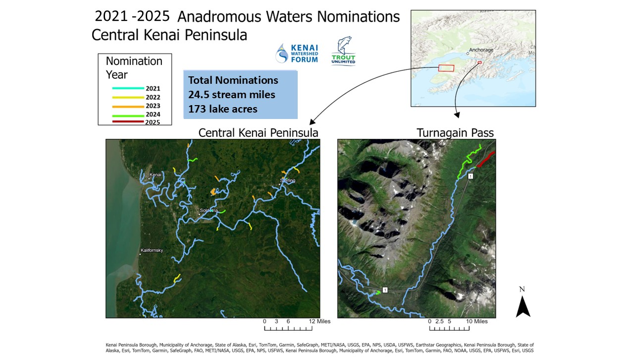
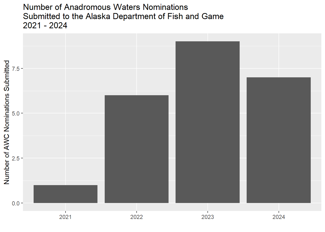
3.2 AWC Nominations
Fish capture data was evaluated against the 2025 Anadromous Waters Catalog to identify new stream segment nominations. Complete submission materials for 2021 - 2023 may be accessed in the project Google Drive folder (link), sent to the ADF&G Habitat Division in Anchorage in the fall of each year. In 2024 we submitted all nominations through the Fish Map App smartphone application from the Alaska Conservation Foundation
Total Anadromous Waters Nominations
As of October 2025, a total length of approximately 24.5 miles of stream segments and 173 lake acres were included in our 25 nominations.
Tables Table 3.4 and Table 3.5 below breaks down each stream segment nomination by length and lake by area.
| nomination_name | nomination | total_stream_length_km |
|---|---|---|
| Soldotna Creek Parcel | 2021 | 1.01 |
| Beaver Creek Trib 1.3 | 2022 | 2.01 |
| Coal Creek Trib 1 | 2022 | 5.20 |
| Crooked Creek Trib 1.1 | 2022 | 0.19 |
| Funny River Rd Trib 1.1 | 2022 | 1.21 |
| KNWR Trib | 2022 | 3.11 |
| Moose River Trib 1 | 2022 | 3.06 |
| Beaver Creek MT #10 | 2023 | 1.32 |
| Clam Gulch Creek 1 | 2023 | 0.47 |
| Forstner Avenue | 2023 | 1.87 |
| Mackey Lakes Culvert | 2023 | 0.48 |
| Moose River Trib 1 | 2023 | 0.75 |
| Moose River Trib 2 | 2023 | 2.57 |
| Moose River Trib 3 | 2023 | 0.74 |
| Savena Lake Tributary | 2023 | 2.38 |
| Unnamed Kenai Trib 1 | 2023 | 1.89 |
| Eagle Rock | 2024 | 0.09 |
| Granite Creek 1.1 | 2024 | 4.23 |
| Granite Creek 4.1 | 2024 | 0.06 |
| Isbell | 2024 | 1.16 |
| Otter Trail | 2024 | 0.02 |
| Sixmile Trib | 2024 | 0.13 |
| Strawberry Rd Corridor 2 | 2024 | 2.15 |
| Granite Creek Trib | 2025 | 3.38 |
| nomination_name | nomination | total_lake_area_hectares |
|---|---|---|
| West Mackey Lake | 2023 | 68.32 |
| Granite Creek Trib Lake | 2024 | 2.08 |
For general background on nominations, see the slides linked here, presented at Kenai Watershed Forum’s Fireside Chat series held at Kenai River Brewing on November 1, 2023.
Or, see the presentation from the 2024 American Fisheries Society National Meeting below on Kenai Watershed Forum’s YouTube channel.

3.3 Volunteer participation
Volunteer recruitment efforts resulted in a steadily increasing level of participation from the general public. A total of 665 volunteer hours were documented throughout the project, with higher outlays in 2021 and 2025 to initiate training.
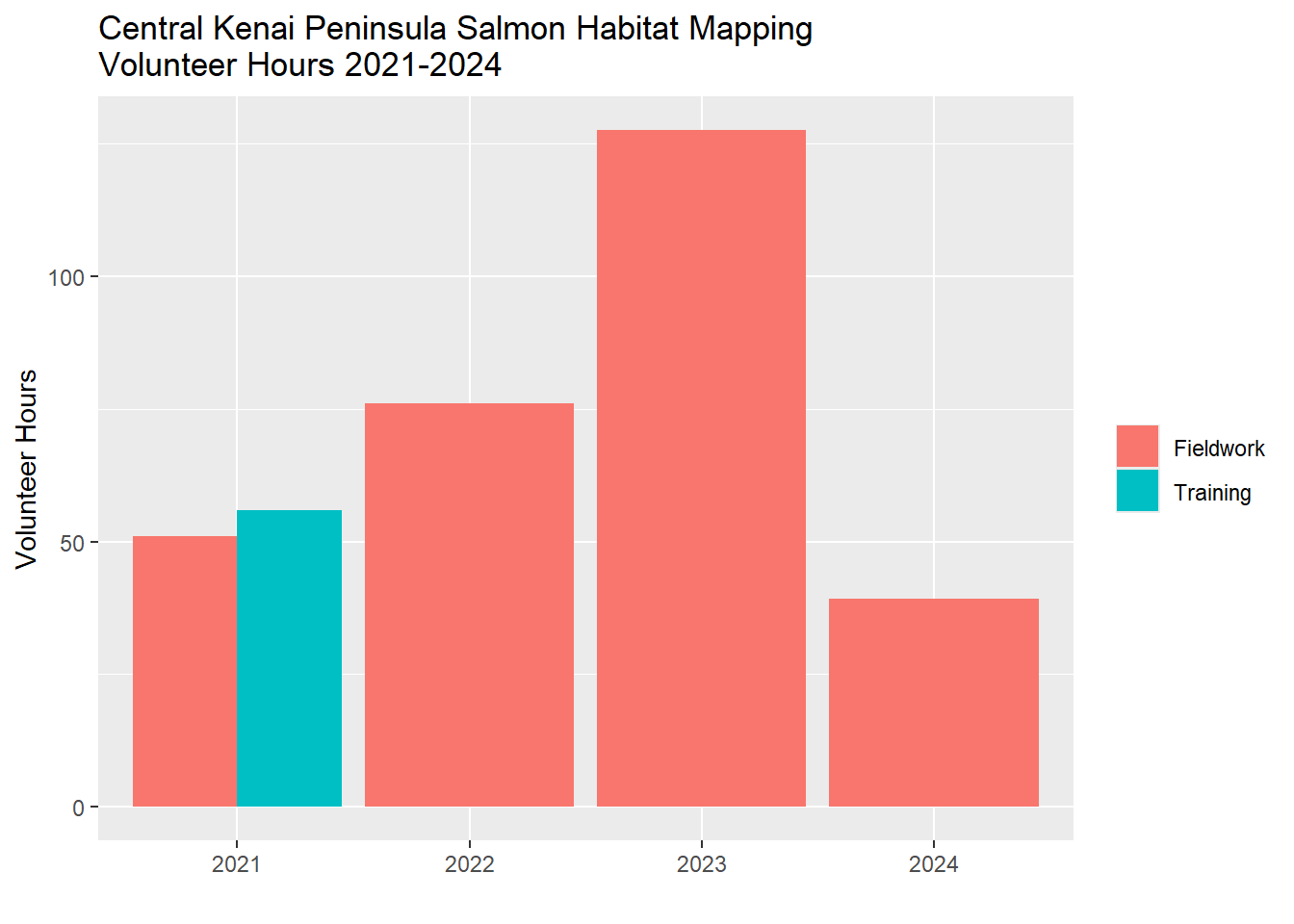
The level of volunteer participation, along with experience gained, mostly tracked the quantity of nominations submitted each year, with a steadily rising number of nominations from 2021 to 2023. 2024 saw very minimal funding resources directed towards fieldwork, thus the number of volunteer hours declined. Despite this reduced funding in 2024, seven nominations were submitted. The result speaks to how sustained financial support, even if fluctuating in amount, is important to keep projects such as this in progress.
In 2025, several training events were held in collaboration with Cook Inletkeeper as part of our shared Backyard Salmonscapes program. Volunteers also contributed efforts to our technical mapping efforts in progress, in collaboration with consultants Terrainworks and Romey Riverscape Sciences. Click here to read more on our new freshwater fish habitat mapping efforts on Kenai Watershed Forum’s website.
3.4 Aquatic Resource Permit
Fish capture data was reformatted each fall in to a csv file for submission to ADF&G in fulfillment of the required Aquatic Resource Permit1; available in the online in this project’s GitHub repo2.